Entities: the units of analysis#
Entities are the units of analysis in openplaces.
They refer to the fundamental building blocks of property information: parcels, buildings, transactions, etc.
In a table or dataframe, entities are represented by rows: each row is a unique entity (e.g., a building).
Most data processed in openplaces is attributed to an entity.
Datasets organized by entities are covered here. For datasets that are not organized by entity (e.g., a global raster image, a text file, or a non-entity table), see datasets.
Building blocks#
Parcels#
Parcels are geo-referenced boundaries that describe a spatial unit of property: a lot of land.
Parcel data is most often created by local land surveyors and tax assessors, typically with the goal of covering all taxable property within a given administrative unit.
Each parcel is indexed by a geometry-derived parcel_id (geo_id), a stable fingerprint that identifies the same lot across data versions and sources.
Buildings#
Buildings are human-built structures with a roof.
Buildings often constitute the largest share of a parcel’s value.
Some buildings are separable from parcels, e.g., a manufactured home.
Hazard risk models often require:
The location of buildings, e.g., for flood risk models.
Structural properties, e.g., for earthquakes, hurricanes, and tornadoes.
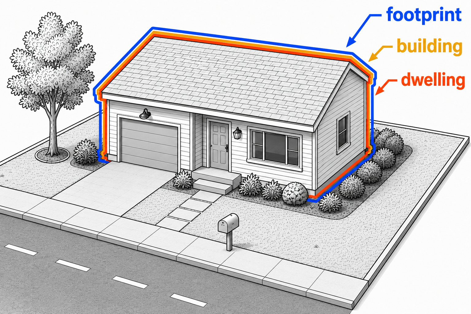
Buildings are neither dwellings nor footprints.
Footprints#
Footprints are the boundaries of a building envelope as seen from space.
Footprints are usually produced from satellite imagery.
An urban footprint, e.g., in New York might contain multiple parcels, each with its own building, e.g., townhomes.
Some hazard models (e.g., for hurricane exposure) operate at the footprint level, e.g., CHEER footprints.
Dwellings#
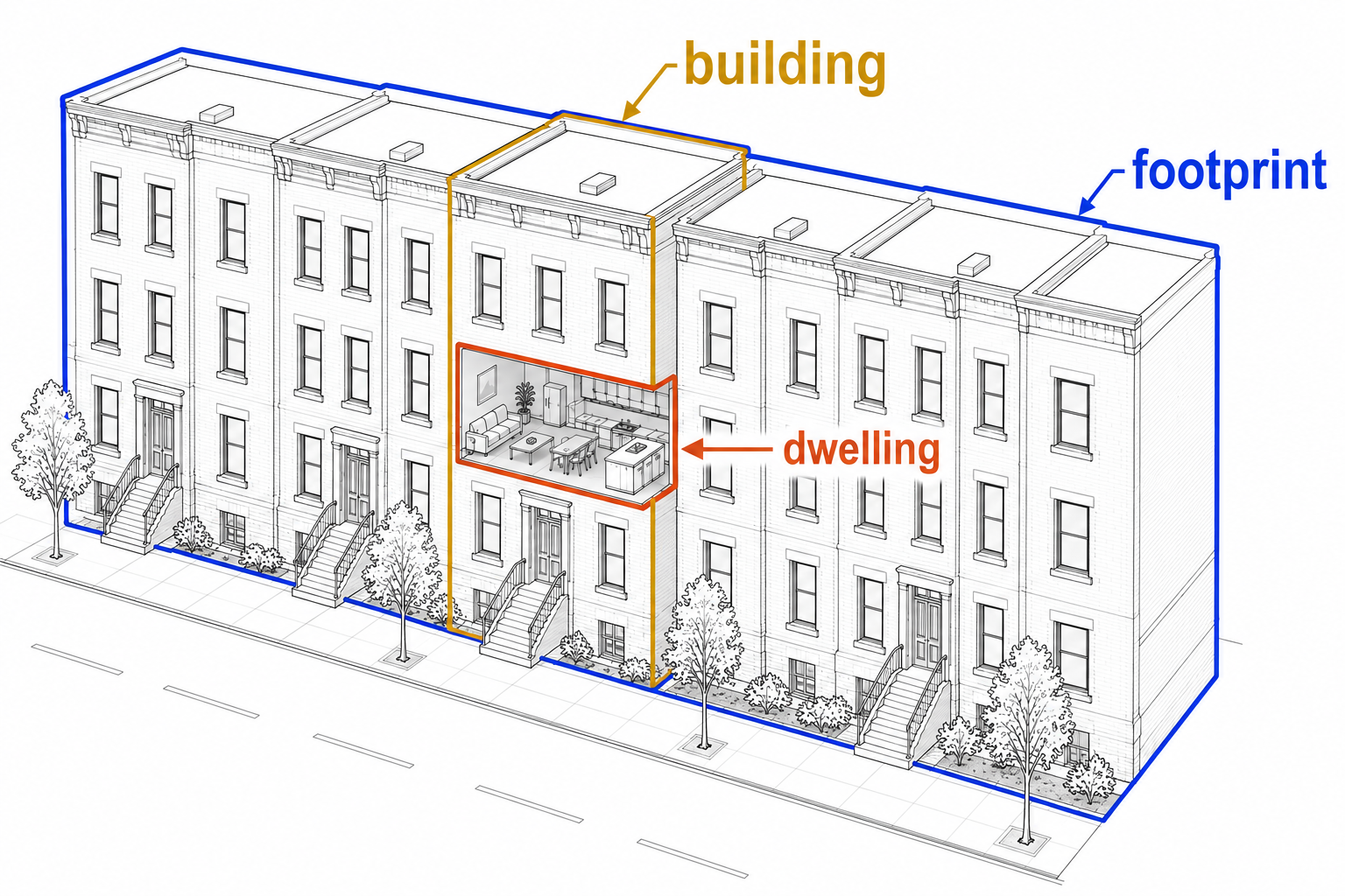
Dwellings are individual residential units within a building, e.g.,:
an apartment in a building.
a unit in a two-family home.
a condominium (separate ownership).
one single-family home.
Address and census databases commonly refer to dwellings.
Properties#
Properties are the assets (property rights) that are sold, valued, and taxed.
The taxable property is the unit by which most tax assessors organize information.
In practice, properties can be any collection of entities. A property can be:
a parcel (excluding any manufactured home on it)
a building (a multi-family unit)
a dwelling (a condominium)
both (a multi-apartment complex)
an entirely different type of asset (e.g., a right-of-way).
Transactions#
Transactions are events in which one or more properties change full or partial ownership.
This typically happens in the form of a sale or easement.
They are recorded in deeds or similar documents.
Transaction data, which may identify the seller, buyer, property, and date, is private in many countries.
Spatial reference and partitioning#
Two types of entities - administrative units and tiles - serve as spatial partitions for data storage and ingestion of other entities.
Administrative units#
Administrative units are a special type of entity. See the section on administrative units to learn how they are defined and referred to.
All recipes belong to an administrative unit (global, country, state, county or similar). Many external dataset downloads are partitioned by administrative units (e.g., US building footprints by state). Most datasets in openplaces are organized by administrative unit.
Tiles#
Tiles are fixed spatial grid cells that cover a geographic area. They are used to partition global or large-area datasets into manageable download and processing chunks.
For instance, OpenBuildingMap serves global building footprints by tile. Global Forest Change serves global raster data by tile.