
U.S. footprint inventory (CHEER)#
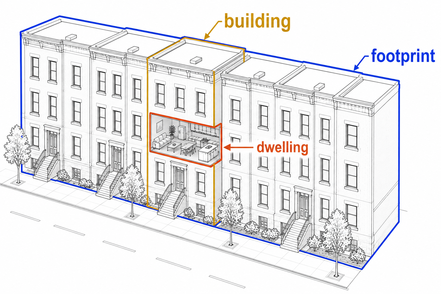
This recipe creates a footprint-level building inventory for hurricane damage and exposure modeling in the U.S.
It first resolves building footprints from multiple polygon sources (OpenBuildingMap, Microsoft, and local datasets), then enriches each footprint with data from linked parcels, the National Structure Inventory (NSI), Overture dwelling addresses, and FEMA’s USA Structures.
It also integrates deep-learning-based recognition of roof shapes and story counts from Google Satellite and Street View imagery (BRAILS++).
The pipeline is currently being tested in Florida, North Carolina, and Texas.
Curation recipe:
src/openplaces/recipes/US/_all/footprint/cheer/2026/US_footprint-cheer-2026.yamlCompanion notebook:
notebooks/examples/US_curate_footprints.ipynb
This work is supported by NSF’s Coastal Hazards, Economic Prosperity & Resilience hub (CHEER).
Output columns#
This recipe produces one .parquet file per county.
Each row represents a deduplicated footprint (or parcel fallback).
Canonical attributes#
footprint_idA unique identifier for each footprint: its 11-digit openlocationcode (duplicate codes receive a numeric suffix, e.g.,
-1,-2, to guarantee uniqueness).geometryThe spatial polygon outlining the footprint, or the parcel polygon for fallback records.
geometry_sourceSource of the geometry:
obm(OpenBuildingMap),microsoft, local state sources (e.g.,nconemap), orparcel.<source>for parcel-shaped fallbacks representing unlocated structures.addressReconciled street address. Prioritizes the assessor parcel address (where available), falling back to Overture dwelling address components, completed with state names derived from administrative units.
occupancy_typeCanonical occupancy class.
Multi-Family structures are split into HAZUS height bands (Low-Rise: 1-3 stories, Mid-Rise: 4-7 stories, High-Rise: 8+ stories) based on
n_stories. Multi-Family rows with no story count keep the plainMulti-Familylabel.valueReconciled structure value in USD. Prioritizes the parcel’s improvement value (apportioned across its primary footprints by floor-area share), falling back to the NSI structure replacement value.
year_builtReconciled construction year. Prioritizes assessor parcel records over NSI block-median fallbacks.
n_storiesReconciled number of stories. Prioritizes street-level imagery predictions (BRAILS++), falling back to NSI modeled counts.
n_dwellingsReconciled count of dwelling units. Prioritizes Overture geocoded address counts over NSI structure counts, falling back to occupancy-class imputation.
heightReconciled building height in meters (where available from the footprint source, e.g. OpenBuildingMap).
roof_shapeReconciled roof structure classification (e.g., Gable, Hip, Flat) from visual models.
m2Calculated footprint area in square meters.
priority_on_parcelStructural role:
primary(main structure),secondary(accessory structure), orunknown(unlinked to parcel).
Provenance sidecars#
Indicates which input dataset or curation rule set decided the final canonical value (later steps override earlier ones). The values contain short method/source strings (e.g., parcel, nsi, overture, imputed, geometry, dwellings, secondary, park, keyword, manufactured_home, brails-2026):
address_sourceoccupancy_type_sourcevalue_sourceyear_built_sourcen_stories_sourcen_dwellings_sourceroof_shape_source
Parcel-derived evidence (assessor)#
Attributes inherited from the primary parcel linked to the footprint.
parcel_idGlobally unique ID of the primary linked parcel, used to join parcels back onto footprints.
parcel_id_local/parcel_id_local_allLocally cross-comparable assessor ID of the primary linked parcel, and combined IDs of all intersected parcels (populated only if more than one distinct ID exists). Not unique across administrative units, so it is not used as a join key.
use_group_combined_parcel/use_group_combined_parcel_allPrimary and combined land-use description strings (populated only if more than one distinct use exists).
land_use_class_parcelCurated parcel land-use classification mapped into 11 potential classes (e.g., Vacant, Manufactured Home, Retail, Office).
occupancy_type_parcelAssessor-proposed occupancy based on property keywords/groups.
occupancy_type_footprint_femaEach parcel’s dominant FEMA USA-Structures occupancy class by overlap area (remapped via the
US_footprint-fema-2023_occupancy-type-remapcrosswalk). Used as second-ranked evidence in the base occupancy cascade.land_value_parcelAssessor land valuation. Kept in full on primary footprints and set to missing (null) on secondary footprints.
improvement_value_parcelAssessor improvement valuation. Apportioned across the parcel’s primary footprints by floor-area share.
year_built_parcelConstruction year recorded in assessor tax records.
address_parcelProperty street address from assessor records (where the parcel geometry source provides it).
overlap_fraction_parcelFraction of footprint area intersecting this parcel.
area_intersection_m2_parcelThe overlap area in square meters between the footprint and the dominant parcel.
n_dwellings_parcelArea-distributed parcel dwelling count from the harmonized spine (may be empty if assessor rolls only exist in the curated parcel lane).
National Structure Inventory evidence (NSI)#
Structure-level point attributes matched to the footprint.
n_buildings_nsi/building_id_nsiCount and ID of matched NSI structure records.
n_dwellings_nsiSummed NSI unit counts per footprint (excluding records flagged to skip upward correction). Serves as a fallback source for
n_dwellings.occupancy_type_building_nsi/occupancy_type_building_nsi_allNSI occupancy class (single matches, and combined list of matches if more than one distinct class exists).
group_building_nsi/group_building_nsi_allNSI occupancy group mapped to openplaces vocabulary (single matches, and combined list of matches if more than one distinct group exists).
structure_value_building_nsiNSI-calculated replacement value of the structure.
year_built_block_median_building_nsiMedian year built for the associated census block.
source_building_nsiUnderlying source database of the NSI record (e.g.,
Model).
Overture dwelling and address evidence#
Residential unit address points matched from Overture.
n_dwellings_overtureTotal count of geocoded residential unit points linked, representing total dwelling units summed across linked address points (address deduplication and multipoint aggregation enabled). Unmatched footprints or those on vacant-use parcels are filled with 0.
address_street_dwelling_overture/address_number_dwelling_overtureGeocoded street name and house number components.
postal_code_dwelling_overture/city_dwelling_overturePostal code and city components.
Diagnostics and special metrics#
Flags and intermediate calculations used for curation and quality control.
n_parcels_per_footprintNumber of parcels intersected by the footprint.
n_footprints_per_parcelNumber of footprints on the associated parcel (includes synthetic fallbacks).
occupancy_type_conflictSummary of conflicting occupancy labels across inputs (formatted
"nsi: X | fema: Y | parcel: Z | overture: W"). This column is only populated where two or more evidence sources disagree. Non-residential classes are collapsed toNon-Residentialbefore comparison, so only residential (or residential-vs-non-residential) disagreements are surfaced.address_conflictSummary of conflicting street address values across input sources, only populated where two or more address sources disagree.
occupancy_type_reviewFlag (
True) for low improvement-value parcel shares indicating potential manufactured homes needing inspection.value_per_area/improvement_value_parcel_per_area/structure_value_building_nsi_per_areaCalculated values divided by footprint area (USD/m²).
manufactured_home_communityBoolean flag indicating whether the parcel is part of a manufactured home community (having more than 3 final Manufactured Home footprints).
n_manufactured_homes_per_parcelThe total number of curated Manufactured Home footprints residing on the same parcel.
Processing pipeline#
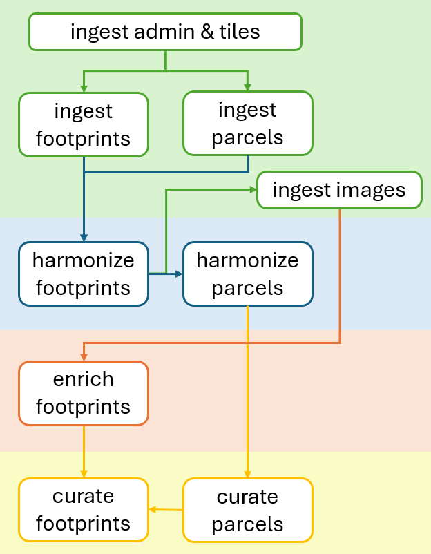
The creation of the CHEER dataset proceeds through the core stages of the openplaces pipeline: Ingest (precursors, then entities, then images), Harmonize, Enrich, and Curate.
Stage 1: ingest#
This stage downloads and extracts raw boundary, tile, geometry, and reference point datasets.
Precursor datasets#
Downloads US Census administrative boundaries (US_admin-census-2021_admin2, US_admin-census-2021_admin3, US_admin-census-2021_admin4) and resolving tile structures (tile-obm-2025). This step generates the spatial indices required to segment raw footprint assets.
Core assets#
Footprint polygon datasets: Downloads and unzips raw footprints from OpenBuildingMap (OBM), Microsoft, and state/local layers.
Parcel datasets: Gathers property tax assessor geometry and tax rolls from local/state agencies.
Reference layers: Downloads structure point databases (National Structure Inventory; NSI), geocoded residential address points (Overture), and FEMA USA Structures footprints (used for parcel-level occupancy evidence).
Stage 2: harmonize#
This stage merges geometries and links datasets to build the core footprint spine (US_footprint-spine-2026) and parcel spine (US_parcel-spine-2026).
Footprint spine harmonization#
Recipe: US_footprint-spine-2026
Creates the spatial exposure units by merging and deduplicating footprint boundaries, linking them to parcels, and attaching point reference data:
Geometry deduplication: Merges footprints in priority order (OBM first, then Microsoft, then state-specific sources). Footprints smaller than 10 m² are dropped. Candidate shapes are added to the spine only if their Intersection-over-Union (IoU) with existing shapes is < 0.02 and they do not fall within a size-scaled exclusion buffer around large existing spine footprints (area >= 250 m²; buffer distance scales with the square root of the area:
keep-out distance= 2 m + 0.5 * sqrt(area)).Elongated-footprint filter: Aspect ratios >= 2.5 with aligned axes (within 15°), longitudinal overlap >= 50%, and lateral spacing < 2x width are deduplicated to prevent parallel-shifted footprint representations (common for manufactured homes) from appearing twice.
Parcel spatial overlay: Intersects footprints with parcels via a polygon identity overlay. Intersections under 10 m² or minor slivers (< 1/6 of the footprint’s largest parcel intersection) are filtered. Systematic spatial displacements between footprint and parcel layers are corrected by snapping chain-displaced footprints to their dominant parcel when minor overlaps are small and land on neighbors with their own buildings.
Synthetic fallbacks: For parcels where assessor records indicate a structure exists but no footprint is detected, synthetic “footprint” rows are created using the parcel boundary geometry (labeled
parcel.<source>). Overlaps against detected footprints are spatial-trimmed. These fallback polygons are included in the parcel footprint count, are backfilled with the ID (parcel_id) and local ID (parcel_id_local) of their source parcel, and are excluded from morphology metrics.Reference point linking: Associates structure-level point evidence with the footprint spine using a tiered proximity join (Lochhead et al. 2026).
Containment: Point is within the footprint.
Inner Proximity: Points within 10 meters of an edge are assigned to the closest footprint.
Outer Proximity: Points within 100 meters (NSI) or 50 meters (Overture) are assigned to the closest footprint on the same parcel, ensuring points aren’t misaligned across street boundaries.
Duplicate Resolution: Colocated duplicate points from low-rank sources (such as outdated ESRI or HAZUS/NSI-2015 records sharing a building ID or location cell with a higher-ranking source) are flagged during the link step and excluded when NSI evidence is merged onto the footprint spine.
Role classification: Footprints on multi-structure parcels are classified to identify primary vs. accessory structures.
Sole footprints on a parcel are always classified as
primary.Footprints with Overture dwelling points are
primary, otherwise footprints with NSI building points areprimary. If no point evidence exists, all footprints on the parcel default tosecondary.Footprints not linked to any parcel are classified as
unknown, unless they carry dwelling-point evidence, in which case they are promoted toprimary.Synthetic, parcel-derived fallback geometries representing unlocated structures are always classified as
primary.Raw attribution: Compiles all raw joined variables into source-suffixed evidence columns in the intermediate spine.
Parcel spine harmonization#
Recipe: US_parcel-spine-2026
Creates the parcel-level matching baseline by compiling land boundaries, merging tax assessor records, and linking point evidence:
Boundary baseline: Merges discovered statewide and local parcel geometry layers into a unified spatial spine.
Assessor records merge: Joins county and local assessment tables by matching local ID keys and standardizing property use codes.
Reference data enrichment: Joins building structures (NSI), dominant building groups, and FEMA occupancy, and counts footprint morphology features (such as primary and small elongated footprints) on each parcel. It resolves colocated duplicate NSI points using the same rules (flagging low-rank twins) to exclude them from parcel aggregates.
Stage 3: ingest images#
This stage fetches external imagery required for deep-learning visual classification, querying the Google API using footprint geometries from the harmonized spine:
Satellite imagery: Scrapes per-building Google Satellite images at Zoom level 20 (
image-googlesatellite-z20) via the BRAILS++ scraper.Street View imagery: Downloads street-level Google Street View photos (
image-googlestreetview-2026).
Stage 4: enrich#
This stage runs deep learning models (BRAILS++) on the ingested imagery to predict visual building attributes (Cetiner et al. 2025):
Roof shape prediction: Runs neural network classifiers on the scraped satellite imagery to predict
roof_shape.Story count detection: Runs detectors on the Street View photos to infer
n_stories.
Stage 5: curate#
This stage curates the spines into clean, canonical datasets.
Parcel curation#
Recipe: US_parcel-openplaces-2026
Curates the parcel spine to produce clean assessor and land-use attributes:
Impute parcel occupancy group: Computes modal building groups per assessor use code using NSI structure counts to fill missing property occupancy groups.
Score relative footprint area: Calculates log-space z-scores of the largest footprint area relative to other parcels sharing the same use code, assisting vacant land and townhome classifications.
Classify parcel land use: Runs multi-indicator voting rules to identify specific land-use classes (such as Manufactured Home Park, RV Park, Townhome, Vacant, Retail, and Office). Townhome classification leverages morphology indicators—specifically the maximum parcels spanned and dwellings contained by a single footprint—combined with assessor keywords to identify shared-footprint row houses.
Reconcile default land use: Determines default land-use class for parcels not claimed by specific rules via consensus voting across three group-vocabulary columns (NSI, FEMA, and parcel use groups).
Derive story count from height: Estimates dominant story counts from LiDAR-derived FEMA footprint heights (approximated as
height / 3.05, rounded and floored at 1).Standardize data categories: Converts string columns to pandas Categorical types.
Format curated parcel schema: Enforces a standard column order on the final curated parcel schema.
Footprint curation#
Recipe: US_footprint-cheer-2026
Integrates curated parcels, corrected address counts, reconciled attribute priorities, base occupancy imputation, visual model prediction, and weighted voting to resolve final footprint occupancy classes. The process is organized into seven functional sub-stages:
Input integration and value apportionment
Integrate clean assessor data: Matches each footprint in the spine to its corresponding curated parcel, joining attributes like land-use class and FEMA metrics.
Apportion parcel values: Joins property valuation and construction year columns from the curated parcel lane, then splits
improvement_value_parcelacross primary footprints by floor-area share and keepsland_value_parcelwhole on the principal footprint only.Collect overlapping parcel IDs: Retains the full n:m footprint-parcel membership as a canonical column (parcel_id_all) from the overlay link sidecar.
Dwelling and address evidence prep
Correct address evidence: Suppresses Overture dwelling unit counts on vacant-use parcels to filter out platted or pre-construction addresses.
Determine implied Overture occupancy: Assigns a temporary occupancy class to
target(occupancy_type_dwelling_overture) based on the corrected Overture count (Single-Family for <= 1 dwelling, Multi-Family for >= 2).
Core value and metric reconciliation
Select canonical values: Resolves conflicts between competing source attributes by selecting canonical values for dwelling counts, construction year, and financial valuation.
Reconcile street addresses: Reconciles and harmonizes street addresses from parcel assessor and Overture dwelling address components, completing missing components (like state names).
Zero-fill address counts: Fills missing or suppressed
n_dwellings_overturecounts with 0.Compute footprint metrics: Calculates structural area in square meters and value-per-area metrics.
Impute missing residential units: Imputes residential unit counts when no matched source evidence exists based on the occupancy base class.
Occupancy consensus and correction
Establish baseline occupancy class: Resolves a weighted consensus vote across present evidence columns (NSI, FEMA, parcel, Overture) where the heaviest class wins. It applies a geometry-based manufactured home fallback and fills residential gaps.
Apply property-use keyword corrections: Refines baseline occupancy using county property-use keyword rules. It also writes the
occupancy_type_parcelcolumn, sets review flags, and creates conflicts reports.
Imagery enrichment integration
Merge visual model predictions: Merges predicted roof shape and story count attributes from visual model recipes.
Reconcile story counts: Resolves conflicts between competing story count sources (visual predictions
n_stories_brailsand NSI block-median countsn_stories_building_nsi) by selecting the canonical value.
Final occupancy voting and refinement
Score manufactured home probability: Computes a probability score for manufactured home classification based on assessor keywords and footprint morphology.
Resolve occupancy by weighted vote: Resolves final occupancy class (specifically Manufactured Home vs. Multi-Family conflicts) to the
targetcolumn (occupancy_type).Split height bands: Splits
Multi-Familyoccupancy into Low-Rise, Mid-Rise, and High-Rise height bands based on the reconciled number of stories.Flag manufactured home communities: Flags parcels containing more than 3 final Manufactured Home footprints.
Schema standardization and formatting
Standardize data categories: Converts string columns to pandas Categorical types.
Cast year built to integer: Rounds and casts the Construction Year column to a nullable integer.
Clean up and order columns: Enforces standard column order and drops transient helper columns.
Technical Annex#
Key references#
Lochhead M, Zsarnoczay A, Deierlein G (2026) Exposure matters: a synthesis framework for high-resolution building inventory development. International Journal of Disaster Risk Reduction 139 (2026): 106148. doi:10.1016/j.ijdrr.2026.106148
Cetiner, B., McKenna, F., Yi, S.-ri, Wang, B., & Manousakis, I. V. (2025). BRAILS++ (v4.2.0). Zenodo. doi:10.5281/zenodo.17797364